Demographic Series: Bay Area
An analysis of the San Francisco Bay Area's racial, ethnic, and socioeconomic demographics
This is the first installation in a series of articles in which I map, analyze, and discuss the demographics of American metropolitan areas using data from the 2020 Census. The series will begin with California’s Bay Area, where I’ve called home for the past five years. Working on these maps has been lots of fun so I’m very excited to kick this off! Please enjoy, and I hope you can excuse the lengthiness :)
The San Francisco Bay Area is one of the world’s most culturally and economically important metropolitan areas, globally known as an artistic and technological hub. The area is home to a vibrant art and music scene, and Silicon Valley is the world’s most prominent cluster of technology companies. With 7.8 million total residents, the nine-county Bay Area is one of the 50 most populous metro areas in the world and ranks seventh in the United States (fifth if the entire combined statistical area is considered); this area posted a GDP of $1 trillion in 2019, outranking all but 16 countries.
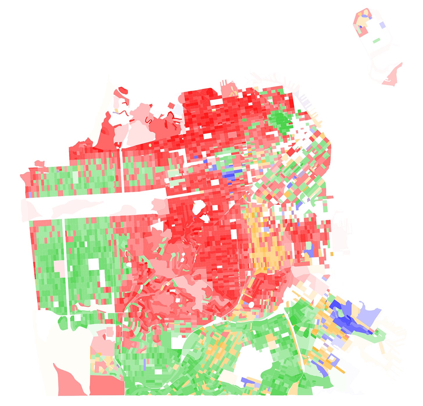
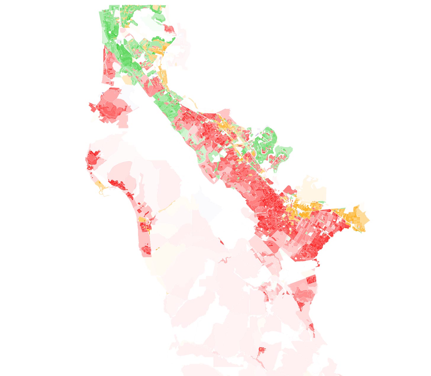
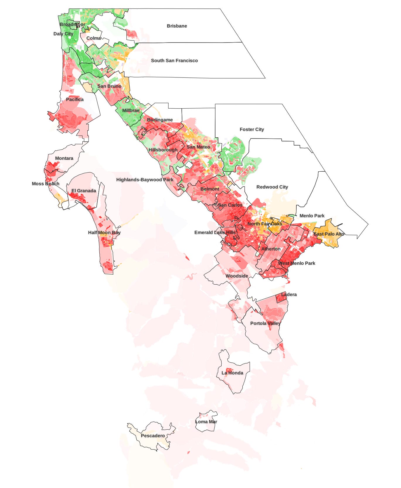
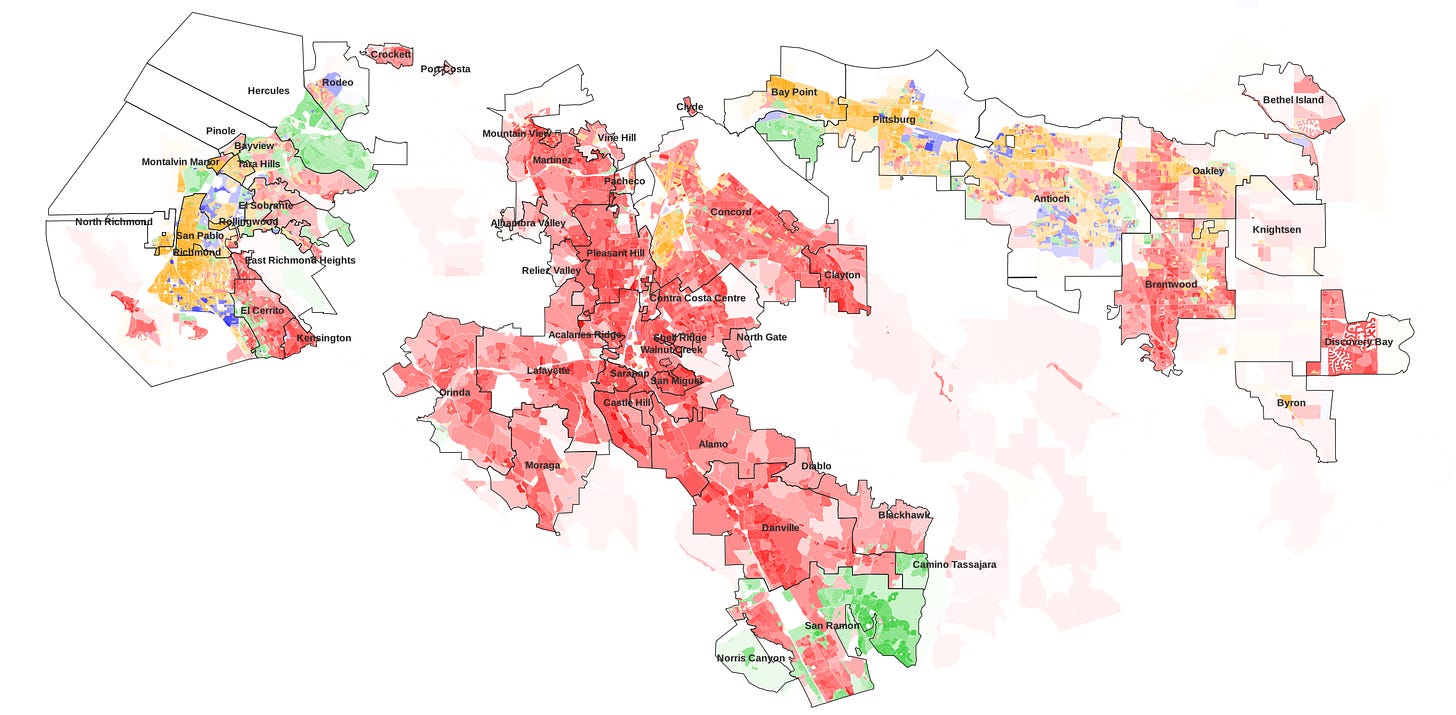
The demographic map below, which I made using QGIS, illustrates the Bay Area’s racial and ethnic diversity and distribution. Each block is colored according to the largest group among its population (red corresponds to non-Hispanic white, green to Asian, orange to Latino or Hispanic, and blue to Black), with increased intensity for higher shares of the population and increased opacity for higher overall population density (and vice versa).
Overall, the Bay Area is 35.8% non-Hispanic white, 31.4% Asian, 24.4% Latino or Hispanic, and 7.4% Black. The rest of this article will delve into regional patterns and specific county- and city-level demographic breakdowns.
San Francisco
2020 population: 874k (+9% since 2010)
39% White, 38% Asian, 16% Latino, 7% Black
It’s only fitting to begin with the central city of the Bay Area. San Francisco is the social and cultural hub of the metropolitan area it anchors, though it’s not the largest, with San Jose’s million-odd population edging it out by a hundred thousand or so people. This consolidated city-county is the second-densest major city in the United States and the fifth-densest county (first outside of New York City). While reasonably diverse, it’s whiter than most of California’s other large cities, with San Diego being the only other city in the state’s top ten where over one-third of residents are non-Hispanic white.
While some neighborhoods are very diverse, ethnic enclaves and other stark differences in racial composition can be clearly identified as well. Non-Hispanic whites dominate in the wealthy northern Marina and Pac Heights neighborhoods as well as in central areas including the Castro, the Haight, and Noe Valley. Asians form the overwhelming majority in Chinatown in the northeast, Excelsior and the Outer Mission in the south, and the Sunset in the west, and the Richmond and Japantown are also predominantly Asian. The Mission is mostly Latino, with a smaller pocket in Excelsior. Fillmore and Bayview are home to most of the city’s few Black-majority blocks.
San Francisco’s most ethnically diverse neighborhoods are unsurprisingly its most working-class, and the majority can be found close to downtown. The Tenderloin is the city’s mainland’s most diverse, at 31% Asian, 28% Latino, 26% white, and 14% Black. Nearby SoMa and Civic Center, as well as Bayview-Hunters Point in the southeast, but all are outdone by Treasure Island.
The 2 sqkm-large island, manmade in the 1930s for the Golden Gate International Expo, was purposed as a naval base for the subsequent several decades. Upon the base’s closure in the 1990s, civilians, mostly low-income (some homeless) San Franciscans who sought refuge from the city’s housing prices, began moving into the island’s affordable and supportive housing. Today, the island’s makeup remains diverse and lower-income, its $59k median household income sitting at just over half of the $104k citywide average. 28% of the island’s roughly 2,700 residents are white, 27% are Latino, 23% are Asian, and 20% are Black. The island is slated for transformative changes in the future, with thousands of homes, hundreds of acres of parks, and numerous other developments slated to be added in the near future, yielding a projected population of 20,000 a decade from now.
While San Francisco is very dense as a whole, some less opaque areas can be identified, indicating lower density. Treasure Island, Twin Peaks and its surrounding hilly areas, and Parkmerced stand out; as well as major parks, such as Golden Gate Park, the Presidio, John McLaren Park, and Lake Merced Park; and commercial areas.
San Mateo County
2020 population: 764k (+6% since 2010)
36% White, 34% Asian, 25% Latino, 3% Black
San Mateo County, encompassing the entirety of the San Francisco Peninsula sans the city of San Francisco itself, is a mostly suburban county situated between the two urban centers of San Francisco and San Jose. The county’s eastern coast is an uninterrupted corridor of cities, while its Pacific coast is much more sparsely populated and its longitudinal center consists of the nearly entirely uninhabited northern portion of the Santa Cruz Mountains.
The immediate San Francisco suburbs, located at the northern end of San Mateo County, are mostly Asian, matching the demographic makeup in the Excelsior area on the other side of the county line. Daly City, which spans most of the county border, is 61% Asian; neighboring South San Francisco is 45%, San Bruno is 36%, and Millbrae is 56%. Colma, a small, diverse town between Daly City and South San Francisco, is a famous necropolis; three quarters of its land is dedicated to cemeteries, and its deceased population of 1.5 million is a thousand times larger than its living population. Directly to its east is San Bruno Mountain, which alongside Colma’s cemeteries is responsible for the glaringly noticeable uninhabited area surrounded by residents. This region is less wealthy than the cities to its south, with Daly City, South San Francisco, and San Bruno boasting three of the five lowest median household incomes in the county at merely $100k, $106k, and $113k, respectively (the countywide average is $128k).
Central San Mateo County is mostly white with a significant Asian minority, though San Mateo also has a sizeable Latino minority. The Asian-majority Foster City juts out visibly on the map, and the meandering paths of its Seal Slough, Marina Lagoon, and artificial Foster City Lagoon, stands out as well. This unique city, built atop a landfill-supplemented Brewer Island in the 1960s, continues to grow quickly to make up for lost time — its 11% growth in the past decade is a blistering pace by the area’s standards — and the Asian share of its population has surged from 35% in 2000 to 57% two decades later.
This area also notably contains the wealthy town of Hillsborough, whose median household income stands at over $250k. Not to be outdone, the town of Atherton, only a half hour drive to the south, likely boasts a median income approaching $400k a year (the Census doesn’t release specific figures beyond $250k, but estimates can be made). Last month, the median home listing price was an outrageous $10.8 million. Both towns are over 80% university-educated and majority-white. Politically, both are ancestrally Republican but swung wildly in the Trump era; Romney carried Hillsborough by 8 points and Atherton by 5, but four years later, Clinton was handed a 40-point margin of victory by Atherton and a 32-point margin by Hillsborough, symbolic of the shifting political coalitions in recent years.
The southern portion of San Mateo County makes up the western portion of Silicon Valley, with locations like Redwood City and Menlo Park (home to Oracle and Facebook, respectively, among others) well-known in the tech world. While Atherton is an outlier, the cities of Menlo Park, Belmont, and San Carlos are also very wealthy. This area is home to highest concentration of Latinos on the San Francisco peninsula; Latinos make up roughly two thirds of North Fair Oaks and East Palo Alto and over one third of Redwood City. The region’s Asian population is smaller than in the areas further north (and further east in neighboring Santa Clara County).
Across the Santa Cruz Mountains lie beautiful sights by the Pacific but much fewer residents. South of Daly City, only just over 60 thousand people live on San Mateo County’s Pacific coast, with nearly two-thirds of that population residing in the aptly-named city of Pacifica. This area, stretching down through iconic Half Moon Bay to remote Año Nuevo Point, is mostly white, with a notable Asian minority in Pacifica, Latino minority in the Half Moon Bay area, and Latino majority in tiny Pescadero, whose total population lies at a mere 595.
Santa Clara County
2020 population: 1.94m (+9% since 2010)
29% White, 42% Asian, 25% Latino, 3% Black
At 1.9 million residents, Santa Clara County is the Bay Area’s most populous and stands 18th in the country. Geographically, it spans most of the Santa Clara Valley, its urban center lying in the heart of the valley, bordered by the Santa Cruz Mountains to the west and the Diablo Range to the east.
The three cities at the western end of the county — Palo Alto, Mountain View, and Los Altos, as well as the adjacent town of Los Altos Hills — are all plurality white and roughly 40% Asian, with few residents of other groups. Mountain View is famously home to the headquarters of Google, which makes up 20% of the city’s employment, and Palo Alto is home to Stanford University.
Just to their east are four Asian-majority cities: Sunnyvale, Santa Clara, Cupertino, and Saratoga. Aside from Saratoga, a mostly residential community, these cities are central parts of Silicon Valley, alongside the aforementioned Palo Alto and Mountain View. Santa Clara is the world’s preeminent semiconductor hub as the home of Intel, Nvidia, AMD, and Applied Materials; Sunnyvale, the founding location of Atari, is the birthplace of the video game industry; Cupertino famously houses the headquarters of Apple. These core Silicon Valley cities are high-income, with all having median household incomes of $136k or greater — Cupertino, at $183k, has the highest median income of any midsize city in the country, with Palo Alto third — and the more residential Saratoga, Los Altos, and Los Altos Hills, where the median household makes over $200k a year, are particularly affluent.
Directly bordering Santa Clara, Cupertino, and Saratoga to the east is the South Bay’s central city and the United States’s tenth largest, San Jose. It’s a culturally, ethnically, economically, and geographically diverse city, with a bustling downtown, business districts, sleepy residential neighborhoods, and even a marshy waterfront below sea level.
At 41% Asian, San Jose is the largest Asian-plurality city in the United States, but it also has significant Latino (31%) and white (23%) minorities. The city’s western side is plurality white, while the eastern and northern areas are heavily dominated by Latinos and Asians. Latinos mostly live in a corridor stretching from the city’s downtown to the Alum Rock neighborhood, while areas to the north and southeast are overwhelmingly Asian. Generally speaking, the city’s central neighborhoods (particularly plurality-Latino areas) are the lowest-income areas in the county, while its outer neighborhoods, spilling over into neighboring cities, are very affluent.
Milpitas, to the north of San Jose, is a quickly-growing suburb on the increasingly-integrated eastern end of Silicon Valley. The city grew 20% in the past decade, primarily driven by an influx of Asian residents — at 74%, the city’s Asian population is the largest by percentage in the country. Southwest of San Jose are the mostly white suburban residential cities of Campbell and Los Gatos.
At the southern end of Santa Clara County, geographically somewhat disconnected from the urban core but certainly still economically integrated, are the cities of Gilroy and Morgan Hill and the village of San Martin. This region is known for its vineyards, wineries, ranches, and orchards, and Gilroy is famous for the annual Gilroy Garlic Festival.
Morgan Hill, the most Silicon Valley-connected of the cities, is plurality white with a significant Latino and Asian minority, while Gilroy is majority Latino and San Martin is plurality Latino. Owing to its plentiful supply of land and relatively lower housing costs, this area is growing quickly. In the past decade, Gilroy’s population increased by 22%, the highest in the Bay Area excluding the East Bay, and Morgan Hill’s increased by 20%.
Alameda County
2020 population: 1.68m (+11% since 2010)
28% White, 36% Asian, 23% Latino, 11% Black
Alameda County, one of two counties that make up the East Bay, is the Bay Area’s second-most populous and fastest-growing county. It contains most of the East Bay’s coastal urban core, stretching across dozens of miles of coastline.
The Tri-City area — made up of Fremont, Newark, Union City — is located at the southern end of Alameda County, at the edge of Silicon Valley. These cities, across the county line from Milpitas, are also predominantly Asian; Fremont (the fourth-largest city in the Bay Area) is 67% Asian, Union City is 62%, and Newark is 45%, with a large Latino minority.
North of the Tri-City area is a plurality Latino but heavily diverse area centered on Hayward, with whiter Castro Valley and more Asian San Leandro to its north and a number of smaller municipalities in between. With the exception of Castro Valley, all have a median household income under $100k, below average for the county and the Bay Area as a whole, with Ashland’s $67k being the lowest in the county.
The county’s inland portion is directly east of this coastal urban cluster, on the other side of the Pleasanton Ridge. Wealthy and suburban, the cities of Dublin, Pleasanton, and Livermore, which form the Alameda County portion of the East Bay’s Tri-Valley region, whites and Asians together form the overwhelming majority of the population here. The three cities’ median household incomes are all in the county’s top five, ranging from $132k to $161k. Between these cities and Fremont is the community of Sunol, a hilly, almost rural area whose population of 922 is spread across an area over half the size of San Francisco.
Dublin, named for its large Irish population in the late 19th century, is the fastest-growing city in the Bay Area, its population increasing by 58% since 2010 and a whopping 142% since 2000. Twenty years ago, when its population was just under 30 thousand, Dublin was only 10% Asian, a proportion which has since skyrocketed to 58% in the city of over 70 thousand — the Asian population increased over tenfold from 3 thousand to 42 thousand in this time. Though this growth is most pronounced in Dublin, adjacent cities in the Tri-Valley area have seen similar increases, with Pleasanton’s Asian population increasing from 12% to 43% in that two-decade span, and San Ramon in Contra Costa County seeing an increase from 15% to 55%.
Oakland, the urban center of the East Bay and California’s eighth-largest city at nearly half a million residents, adjoins San Leandro to the north. At 29% Latino, 27% white, 24% Black, and 19% Asian, Oakland is arguably the most diverse major city in the country. Its diversity and history make for an incredibly culturally rich city, with a blend of immigrant communities, an established culinary tradition, and the highest concentration of artists in the country.
North Oakland is predominantly white and middle-class, and West Oakland is very diverse with a Black plurality; while demographically different, these neighborhoods are the city’s strongest progressive bases. Just east of West Oakland is the city’s vibrant downtown, adjacent to Lake Merritt and the waterfront. Downtown Oakland is home to Chinatown, which like San Francisco’s Chinatown features many blocks where Asians exceed 90% of the population, and Frank Ogawa Plaza, the site of numerous major political demonstrations.
Racial and ethnic enclaves continue further southeast in the city. The San Antonio district is mostly Asian; Fruitvale, Melrose, and Elmhurst are mostly Latino; and the Eastmont area inland from Elmhurst is mostly Black. While the Black population here is the most concentrated in Northern California, Oakland once boasted a much larger Black population of nearly 50%, but a combination of immigration in the late 20th century and rising housing costs have resulted in a decline in Black Oaklanders and increasing gentrification, a problem plaguing more and more parts of the Bay Area.
As with most of the Bay Area, inland parts of Oakland are wealthier and whiter. The Oakland Hills are home to an affluent population mostly living in single-family homes; the racial divide on either side of the 580 freeway is stark, and while East Oakland’s median household income is roughly $50k, virtually all neighborhoods of the Hills boast six-figure medians. While most of this area is in Oakland, a small part forms the separate, enclaved city of Piedmont, which is 63% white and has a median income of over $250k.
Located on an island south of Oakland’s waterfront is the city of Alameda, which is mostly white and Asian. To Oakland’s northwest is the fast-growing commercial city of Emeryville, home to a sprawling range of business districts, resulting in a daytime doubling of the city’s population.
The cities of Berkeley and Albany are situated at the northern tip of Alameda County, with Berkeley sharing its southern border with Oakland and Emeryville. Berkeley is famous nationally and even globally as a hotbed of political progressivism and activism and the home of UC Berkeley. Berkeley delivered the largest victory for Biden of any United States city with over 93% of the vote, and in 2016, Trump won less votes than Green Party candidate Jill Stein here.
The city is almost exactly 50% white, with Black and Latino residents concentrated mostly in the lower-income southwest and coastal neighborhoods, Asians forming the plurality in the student-heavy Southside neighborhood just south of UC Berkeley’s campus as well as in parts of downtown, and whites most dominant in the Berkeley Hills in the city’s northeast and southeast, areas which are ethnically and economically similar to the Oakland Hills. Albany is demographically very similar to northwest Berkeley, with a white plurality and a large Asian minority.
Contra Costa County
2020 population: 1.17m (+11% since 2010)
39% White, 22% Asian, 27% Latino, 11% Black
Contra Costa County, which comprises the northern half of Alameda County, is one of the most fascinatingly varied counties in the United States. Thanks to the Berkeley Hills and the Diablo Range, the county is essentially split into three parts, each of which forms its own unique urban cluster.
West County, which faces the Bay and Marin County to the west, is a very diverse, working-class range of coastal cities centered on Richmond. The region is 37% Latino, 23% Asian, 22% white, and 17% Black, and its population of 275k is just under a quarter of the county total. Fairly out of place here is the community of Kensington, an affluent residential area of roughly five thousand adjacent to the Berkeley Hills, which counts many Berkeley professors among its mostly white population. West of Kensington and north of Albany lies El Cerrito, whose makeup is similar to Albany, with a middle-class, mostly white and Asian population.
At 116k residents, Richmond makes up nearly half of West County and is one of Contra Costa County’s three midsize cities. Richmond is an industrial city whose largest employer today is Chevron, which operates a controversial refinery (whose workers are currently on strike) with unsafe practices that have resulted in long-term spars with local government. The city is also the county’s left-wing hub; it’s the only city in the United States with a socialist-majority city council and was recently the country’s largest city with a Green Party mayor. Though Richmond, like Oakland, was once close to majority-Black, Latinos form the plurality today (with significant Black, Asian, and white minorities), as in the enclaved city of San Pablo.
The more suburban communities north of Richmond are also very diverse; in Pinole and Rodeo, no racial or ethnic group makes up more than 30% of the population, though Asians are a majority in Hercules.
Traversing eastward on highway 4 brings one to the Diablo Valley, one of the three subregions that make up central Contra Costa County. With typical suburban features, Central County is whiter and wealthier than the regions to its west and east. As a whole, 54% of the region is white, 25% is Asian, 15% is Latino, and 4% is Black.
The Diablo Valley, which is majority white but with significant Latino and Asian minorities, is a middle-income-to-affluent area of 317k residents, with lower-income areas by Martinez’s industrial waterfront areas and in the mostly Latino neighborhoods of western Concord and higher-income areas in the foothills of Clayton, eastern Walnut Creek, and western Pleasant Hill.
West of the Diablo Valley lies the Lamorinda area, named after its three cities: Lafayette, Moraga, and Orinda. This hilly region is two-thirds white and has 62k residents, most of whom are wealthy, university-educated homeowners enticed by the area’s relative remoteness and large, spread-out plots of land.
The southern part of Central County consists of San Ramon Valley, which alongside the Amador and Livermore Valleys in Alameda County makes up the Tri-Valley region. Like the rest of the Tri-Valley, the San Ramon Valley is mostly white and Asian; the quiet but quickly-growing city of San Ramon is majority-Asian, like the adjacent city of Dublin, while Danville and Alamo to its north are overwhelmingly white. This area, whose population is 165k, is the second-wealthiest area of the county, behind Lamorinda.
East County is a unique region of suburban-to-exurban character, whose population of 347k is 37% Latino, 29% white, 17% Asian, and 17% Black. The communities along the Suisun Bay on the county’s northern shore exemplify the changing makeup of the Bay Area. Once overwhelmingly white and exurban or even rural, the communities of Bay Point, Pittsburg, Antioch, and Oakley (as well as the more inland Brentwood) have diversified and grown drastically and become interconnected with the Bay Area’s urban core in recent decades as low-income, non-white residents of central cities such as San Francisco or Oakland are increasingly priced out and displaced into more affordable areas.
Antioch, once a sundown town which burned down its Chinatown and expelled its Chinese residents, is today one of the most diverse cities in the country. As recently as 1970, when its population was a mere 28k, Antioch was nearly 90% non-Hispanic white; today, at 115k residents, it’s 36% Latino, 24% Black, 23% white, and 16% Asian. In those 50 years, the city’s Asian population increased from 232 (0.7%) to 19 thousand, and its Black population skyrocketed from only 42 (0.1%) to 28 thousand. Antioch’s neighboring cities have experienced similar transformations, and the area continues to grow — all five communities grew by over 10% in the past decade, with three growing by over 20%.
East of Oakley and Brentwood lie the final remnants of East County’s rural past, with a number of tiny communities in farming and ranching areas that remain the only remaining Republican-voting areas in the Bay Area outside of northern Solano County. Knightsen and Byron, each numbering just over a thousand residents, are mostly white and Latino, their makeup resembling many Central Valley towns both ethnically and economically, perhaps unsurprising given the area’s close geographic connection to the Central Valley.
This region is also home to Bethel Island, a small community located on an island in the middle of the California Delta; and Discovery Bay, a unique planned community built on a network of man-made dikes (clearly visible on the map), with each home having its own waterfront and private dock.
Solano County
2020 population: 453k (+10% since 2010)
34% White, 20% Asian, 28% Latino, 17% Black
Solano is perhaps the least-known of the Bay Area’s nine counties but is certainly not lacking in history or culture. The diverse county stretches from the San Pablo Bay waterfront through hills and marshes to the western end of the Sacramento Valley, its northern tip reaching into UC Davis’s campus adjacent to Yolo County. While it is geographically at the eastern end of the North Bay, Solano County is considered by some to be part of the East Bay due to its cultural and demographic similarities.
Vallejo, located by the Bay at the county’s southwestern tip, has been dubbed the most diverse city in the United States, and for good reason. At 28% Latino, 27% Asian, 23% Black, and 21% white, the working-class city of 126k is home to a rich blend of cultures. Vallejo has one of the largest Filipino communities in the United States, outranked only by Daly City and adjacent American Canyon among cities in the lower 48; unlike in most other Bay Area cities, where the majority of the Asian population is Chinese or Indian, Filipinos make up over three-quarters of Asian Vallejoans. Neighboring Benicia is majority-white — one of only two such cities in the county — and more affluent, the only city in the county with a median household income over $100k. Both Vallejo and Benicia are former state capitals of California; each housed the capitol for a year in the 1850s before it was handed off to Sacramento.
In the center of Solano County, separated from Vallejo and Benicia by the Howell Mountains, are the cities of Fairfield and Suisun City, situated by the Suisun Marsh. Though similarly diverse to Vallejo — the cities are 31% and 29% Latino, 23% and 25% Asian, 19% and 23% Black, and 28% and 23% white, respectively — this area is more exurban in nature. Comparatively, it is less integrated with the urban Bay Area, more connected to the Central Valley, and has grown more rapidly, with the two cities’ combined population jumping from 4,000 in 1950 to 150,000 today.
Vacaville, at the intersection of the Bay Area and the Central Valley, is just to Fairfield’s north. Though it is still fairly diverse, nearly half of the city is white, with smaller Black and Asian populations compared to the cities to its southwest. It’s also the most conservative midsize city in the Bay Area, only narrowly voting for Democratic presidential candidates in recent elections.
The area to Vacaville’s east, mostly farmland, is home to two small cities: to the northeast, Dixon, a farm town located about halfway between Vacaville and Davis with a population that’s equal parts white and Latino; and to the southeast, Rio Vista, a rural, mostly white, relatively lower income community on the banks of the Delta.
Napa County
2020 population: 138k (+1% from 2010)
50% White, 10% Asian, 35% Latino, 3% Black
Napa County, immediately west of Solano, is by far the least populous in the Bay Area but is known globally for its thriving wine industry. With most of its land covered by wineries and mountains, the county is relatively sparsely populated, demonstrated by the few densely populated spots on the map.
The majority of the county’s residents live in the city of Napa, a city of 79k situated on the Napa River close to the San Pablo Bay. Napa is 52% white and 40% Latino, its relative lack of Asian population emblematic of this region’s disconnect from the portions of the Bay Area to its south.
At the southern end of Napa County, adjacent to Vallejo and the Napa River wetlands, is American Canyon, the county’s second largest and most diverse city. At 40% Asian, American Canyon is home to two-thirds of the county’s Asian population, most of whom are Filipino, as in Vallejo. The city also has significant Latino and white minorities.
Most of Napa County’s wineries lie to the city of Napa’s north, clustered around a roughly 30-mile-long stretch of highway toward the northwest. A number of small communities are located along this route, including Oakville, Rutherford, St. Helena, and Calistoga, all of which, like Napa, are mostly Latino and white; and the overwhelmingly white Yountville. These areas are sparsely populated and their economies revolve primarily around tourism and the wine industry.
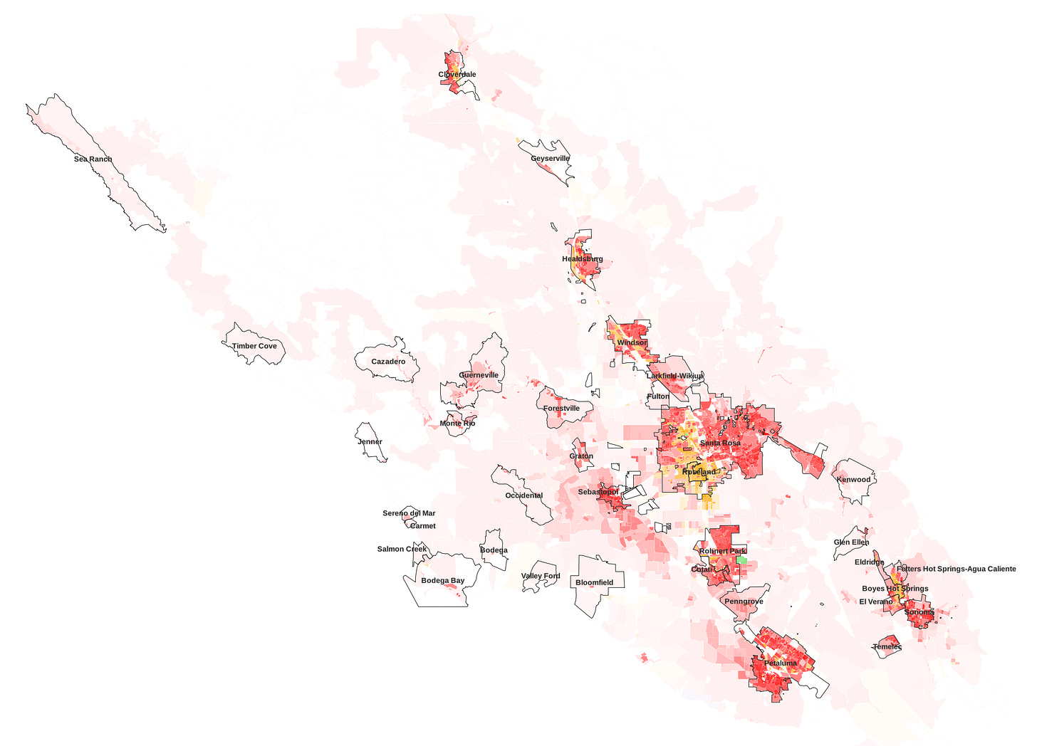
Sonoma County
2020 population: 489k (+1% since 2010)
58% White, 7% Asian, 29% Latino, 3% Black
Sonoma County is the Bay Area’s largest by land area, stretching 50 miles north from the San Pablo Bay to the edge of the North Coast’s cannabis-producing Emerald Triangle. Like neighboring Napa County, Sonoma is a less densely populated county with a suburban feel and agriculture a central part of its economy.
Along with Napa, Solano, Mendocino, and Lake Counties, Sonoma makes up a part of California’s Wine Country; as with Napa, most of Sonoma Counties’ wineries are concentrated in the northern, more rural part of the county, dotted by small, mostly white and Latino communities like Cloverdale, Geyserville, Healdsburg, and Windsor.
South of this area lies the city of Santa Rosa, the largest in the county and the North Bay more broadly, and the Bay Area’s fifth largest. Its mostly middle-income population of 178k is roughly half white and one-third Latino, with small Asian and Native communities; the portion west of the 101 is plurality Latino, while the city’s eastern side is overwhelmingly white.
Sonoma County’s Pacific coast is, as in the rest of the Bay Area, sparsely populated, overwhelmingly white, and very liberal (delivering the largest margins for Democrats in the county, with over 80% voting for Biden), though much less wealthy than the corresponding parts of San Mateo County. A number of small communities, none larger than 1,200 residents, are scattered along the county’s western shores. The similarly white and liberal small city of Sebastopol lies between the Pacific coast and Santa Rosa, at the foot of the mountain ranges that separate the Sonoma Valley from the ocean.
The county’s second- and third-largest cities, Petaluma and Rohnert Park, respectively, sit to Santa Rosa’s south along the 101. Rohnert Park is demographically similar to Santa Rosa, while Petaluma, close to the Marin County Border, is much whiter.
In contrast to Napa, Sonoma’s agriculture industry is fairly diverse; while wine makes up most of its agricultural product, the county is also home to a significant amount of dairy and poultry farming industry, both of which are primarily based in the Petaluma Valley; Petaluma is home to two major locally-known brands, Clover Sonoma and Petaluma Poultry.
Marin County
2020 population: 262k (+6% since 2010)
66% White, 9% Asian, 19% Latino, 4% Black
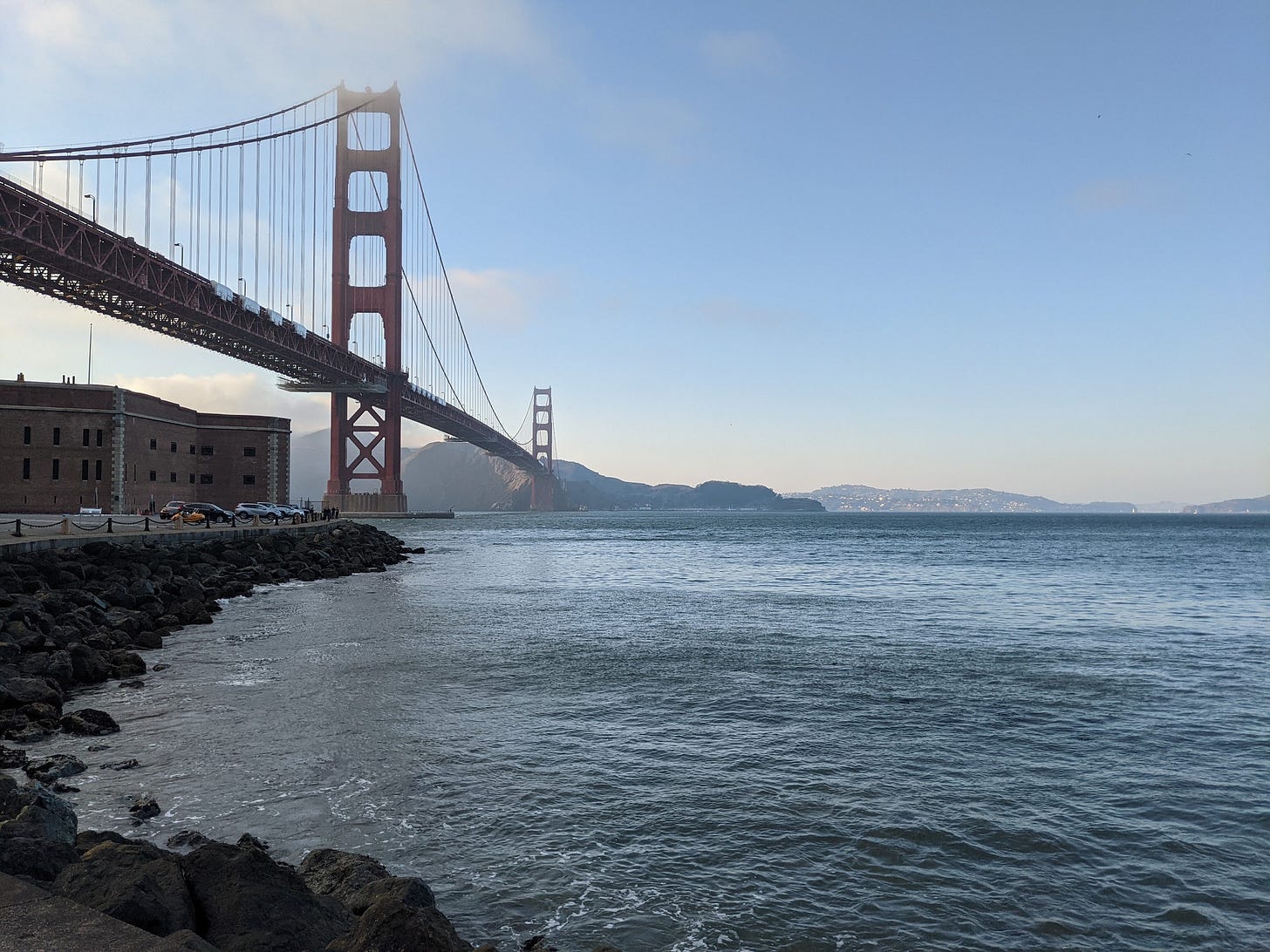
Marin County, across the Golden Gate Bridge from San Francisco, is one of the wealthiest counties in the United States. With its relative seclusion and beautiful views but close proximity to San Francisco, it’s well-known as an old money oasis for rich, white Bay Area families; at nearly two-thirds non-Hispanic white, it’s the least diverse county in the Bay Area.
Marin is a historically Republican county, owing to its wealthy, suburban nature; in 1956, it delivered Eisenhower his fifth-best performance in the state. But by the later stages of the 20th century, a rightward-drifting Republican Party and the county’s burgeoning hippie culture sent Marin County barreling toward the Democrats, and by 2020 it became the second-most Democratic-leaning county in California, after San Francisco, having fully traded its moderate Republican brand for moderate Democratic politics instead.
Like San Mateo to its south, the overwhelming majority of the county’s population resides along the Bay, with few residents on its mountainous, coastal western shore. This area features a number of parks and protected areas, such as Point Reyes National Seashore, as well as the popular Muir Woods National Monument and Golden Gate National Recreation Area at the peninsula’s southern tip.
Novato and small neighboring Black Point-Green Point, downstream from Petaluma along the Petaluma River, are the northernmost and least Democratic-leaning communities in Marin, with Biden winning a mere 75% of the vote in the former and 70% in the latter.
A few miles south of Novato, the Marin’s second largest city, lies San Rafael, the county’s largest. San Rafael is the and its adjacent small suburbs make up nearly half of the county’s population. Over one-third of the city’s population is Latino, with noticeable predominantly-Latino pockets around and east of its downtown.
Just south of San Rafael’s waterfront is the men-only San Quentin state prison, California’s oldest prison, which until the recent moratorium housed the state’s death row. Indicative of inequalities in the police, justice, and prison systems, San Quentin is nearly half Black, one of only two plurality-Black areas in the county.
Most of the communities south of San Rafael, situated along and near the southern half of Marin County’s eastern shore, are overwhelmingly white and wealthy. While San Rafael and Novato are less than 60% white and have median household incomes of around $100k, the communities south of the Richmond bridge average over three-quarters white with median incomes approaching $200k.
Communities in this area include Tiburon, Mill Valley, and Tamalpais-Homestead Valley, situated around the small Richardson Bay, all of which have median incomes above $170k. Belvedere Island, connected to Tiburon by two causeways, is historically a particularly high-income community, with a current median income of nearly $250k.
This region contains one outlier: Marin City, a low-income, highly diverse community situated adjacent to Tamalpais. This small community of three thousand is 34% white, 31% Black, 17% Latino, and 17% Asian, with a median household income of less than $50k, one of the lowest in the Bay Area. Built in 1942 to house wartime shipyard workers who migrated from around the country, Marin City developed into a primarily Black community after the war as most Black workers remained even as others moved elsewhere, largely due to exclusionary zoning laws that prevented them from living in surrounding areas, and with wartime jobs gone, the community struggled. By 1970, it was 75% Black; while displacement and immigration has led to a drastic reduction in this percentage, Marin City remains a microcosm completely unlike its surroundings in ethnic, cultural, and economic makeup.
Sausalito, which like other Richardson Bay communities is mostly white (though it is not as wealthy as some others) lies to Marin City’s south. The first city that drivers heading north from San Francisco see upon entering Marin County, Sausalito is a major tourist attraction. To its south lies the iconic Golden Gate Bridge and the City and County of San Francisco.









This was fascinating, thank you for writing!
I was an enumerator for the Census Bureau in 2020. I enjoyed reading your perspective and analysis meshed with Census data. Great work!